3.2.1. Rules for drawing administrative divisions
You must follow these rules when drawing an administrative division:
3.2.1.1
Draw borders in accordance with the general techniques for drawing composite polygonal items.
3.2.1.2
Borders are drawn in accordance with 2.7.1. General rules for drawing polygonal items.
When drawing and editing administrative divisions, we recommend that their boundaries do not pass through items of the Buildings
category.
Note
When drawing the borders of administrative divisions, border bends are not artificially rounded (the Round all corners operation). Smooth rendering is only applied to the rounded contours of hydrographic items and island coastlines if administrative division borders match them.
3.2.1.3. Sources of information
3.2.1.3.1
Draw administrative divisions based on information about official borders. Main sources of information (if their use does not violate the rules for using third-party sources of information; see Section 3.1.2.1.2):
- General city maps (on the official site for that administration, including city planning management)
- Various legal documents attesting to changes in division borders, to the re-categorization of villages as sub-districts or vice versa (on official websites)
- Descriptions of borders (on official sites)
- Open cadastral state maps.
- Layouts, signs, or resolutions of organizations that have given unofficial names to streets or addresses on their territory.
If there is no official data, you can use the following additional sources:
- Topographic or other paper maps
- Electronic maps in the public domain
- Yandex maps
- Other maps or diagrams
Note
Statistical units (for example, polling stations) are not drawn on the map as administrative division units if located within a locality.
If a statistical unit is essentially a locality (there is no locality this statistical unit could be attributed to), it is displayed as a locality. For instance, Bear Creek, a census-designated place in Alaska (USA), is an example of a statistical unit that is drawn as a locality.
3.2.1.3.2
If there is no information about the location of an administrative border, then follow this advice:
- Borders should not run through fields, woods, and so on.
- It's preferable to make borders circumscribe land plots surrounding residential buildings.
- It's preferable not to make borders run through buildings, structures, or land plots surrounding residential buildings.
- If a locality runs along a riverbank, then its border may either run along the riverbank or through the middle of the riverbed. This applies in cases when the outlines of development areas can't be distinguished on a satellite image.
- Shared borders of administrative divisions must not intersect.
- Use one line to map shared borders of administrative divisions (rather than two parallel lines).
3.2.1.4
When drawing administrative divisions:
3.2.1.4.1
Administrative divisions should be unique. Map items with the same name should differ by type or by their location within the administrative division.
Exceptions to this rule are allowed in the following cases:
-
When two or more administrative divisions in Kazakhstan, Uzbekistan, or Kyrgyzstan have completely identical names, and it's impossible to associate them with different parent map items because the official sources don't contain this information (nor any other information that would justify making these administrative divisions unique).
-
When the proper name of the given administrative division is unknown (for example, in the case of garden plots).
3.2.1.4.2
All administrative units must have a parent map item (see attribute description 3.2.2.3. Administrative submission), where the administrative unit (the parent) must fully include the child administrative units.
3.2.1.4.3
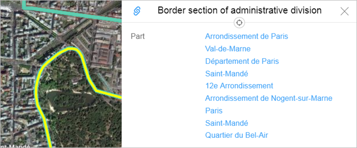
Administrative division polygons may partially overlap with each other, and a specific section of an administrative border may also form part of several other polygons:
3.2.1.4.4
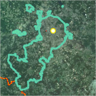
Administrative division borders should be closed.
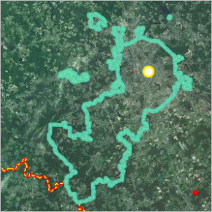
They may, however, be mapped as several closed polygons. For example, the federal city of Moscow
consists of several closed polygons (highlighted in the drawing):
3.2.1.4.5
In some cases you can draw an administrative division without using a polygon (i.e. you can just mark the division's center instead): In this case, place the center in the approximate geometric center of the item you're drawing, while it should be outside the roadway for named road intersections if possible.
You don't need to draw polygons for the following types of administrative divisions:
-
Individual homes and small structures on farms that have proper names but no numbered addresses.
These are level 7 administrative divisions (Blocks).
-
Residential complexes consisting of one building as well as buildings with proper names that are not architectural monuments.
These are level 7 administrative divisions (Blocks).
-
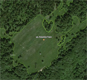
Previously inhabited areas where the territory of anthropogenic influence cannot be discerned via satellite imagery.
These are level 6 administrative divisions (Named territories).
If the boundaries of these divisions can't be defined, only map the center of the administrative division, without a polygon:
-
Administrative divisions that are located in the same development area as municipalities and don't have documented borders (for example, mevkii and semty in Turkey).
These are level 6 administrative divisions (Named territories).
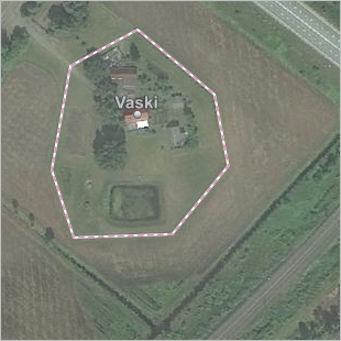
-
Crossroads and small at-grade junctions with proper names.
Such crossroads and junctions are considered level-6 administrative divisions (Named territories).
In addition to marking the center for this type of administrative division, you can also represent it using a polygon.
For example, a private named farmstead in Latvia:
3.2.1.5
When drawing administrative divisions, you can indicate the position of the item's center (see 3.2.3. Drawing centers of administrative divisions).
The center of an administrative division should be located within that division's polygon. If that item consists of several polygons, then the center should be inside one of them.
The center of an administrative unit should be marked in the geographical center of that item on the map (or close to it).
Deleting a previously drawn center is considered an error.
3.2.1.5.1
You can't put the center of a division inside a building polygon if it will cover over address points and other places.
Administrative divisions that can be drawn without using polygons (see 3.2.1.4.5) and centers of administrative divisions that are territories giving names to streets and addresses (such as garage co-ops) are the exception to this rule. In this case, the administrative center should be placed within a building polygon.
3.2.1.5.2
The center of an administrative division of the locality
type is placed:
- On the central square of the locality (if this will be legible on the map)
- In the center of the oldest fortress or kremlin of that locality (especially if that fortress/kremlin is the main attraction in that locality)
- Next to one of the central intersections of that locality (it's preferable not to place it directly on the road or intersection, but rather in the vicinity of it)
3.2.1.5.3
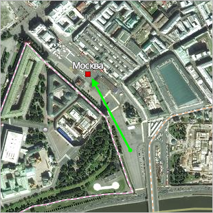
If the historical center of an administrative division unit of type locality
does not match its geometric center, then the map should reflect the actual historical center. For example, in Moscow the historical center is Red Square:
|
|
|
If a locality consists of several areas that form different building developments, then mark the most important area as the center (based on the rules given in point 3.2.1.5.2).
3.2.1.5.4
If the geographical center of a city district
is in an industrial or undeveloped territory, then draw the center on the territory of a residential development within the borders of that administrative division.
3.2.1.6
When drawing internal polygons, follow 2.7.2. Rules for using internal polygons.
3.2.1.7
The rules for drawing administrative divisions that don't have clear borders are established in the administration documentation (for blocks, named territories, etc.):
3.2.1.7.1
If possible, draw administrative divisions as a single polygon.
You can make an exception in cases where the city is divided by a big park, river, industrial zone, or similar object, or the locality contains districts that are at some distance from the main area of development.
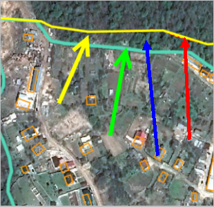
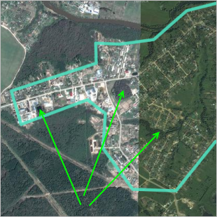
Draw block borders (marked with a green arrow) based on the building development polygon and do not include fields and other territories that share a border with the block (blue arrow) even if they belong to the official territory of that locality (red arrow):
3.2.1.7.2
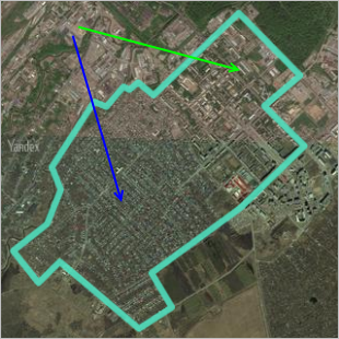
Draw the territories of multi-storey and individual buildings the same way. Use a single polygon to draw blocks that contain both multi-storey (green arrow) and individual (blue arrow) buildings:
3.2.1.7.3
An administrative district polygon may contain items that don't have a specific territory. This includes small areas of vegetation in courtyards and small hydrographic items such as ponds, small rivers, and streams:
3.2.1.7.4
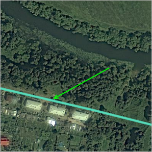
If an administrative division is bordered by large objects, such as a river or a body of water, woodlands, industrial site, agricultural land, or railways, then its border runs along the edge of the building plots. If it's impossible to distinguish the outlines of the areas at the border of a locality, such as an unfenced industrial area, then the border is drawn along the edges of large objects:
3.2.1.7.5
When mapping terrain, keep in mind that items can be drawn in the administrative division or in the vegetation layer depending on the situation.