3.1.1. Map item selection rules
3.1.1.1
-
Draw items that exist in reality (both concrete items like homes, roads, bridges, etc., as well as immaterial borders of localities, sub-districts, etc.)
Draw physically existing items along the borders of their projection on Earth's surface.
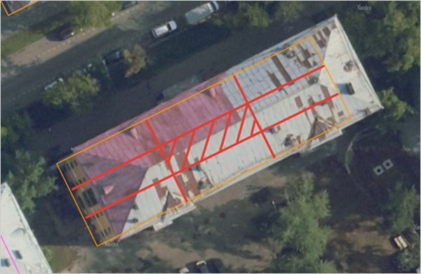
For example, when drawing items located on stylobates or building roofs, make sure they match the geometry of the stylobates or roofs. If necessary, shift them to match shifts in the stylobate or roof polygon drawn on the map:
3.1.1.2
- Items you draw should have defined borders. For example, you can't draw
the area around item N
since that area does not have definite borders.
3.1.1.3
-
Non-existent items (shifted borders, demolished or planned buildings, etc.) should not be mapped unless they relate to one of the exceptions listed below.
-
3.1.1.3.1
- Demolished or partially demolished map items are still considered to "exist" for as long as remnants of that item are still at the site (for example, if the foundation of a demolished building is still there) and nothing has been built or is in the process of being constructed in their place.
3.1.1.3.2
-
Items of any type that are under construction "exist" and can be drawn on the map as soon as the construction site for that project goes up.
Do not draw items that are still in the planning stages (i.e. before construction has started).
-
Note
Items of the
Building
type are only drawn when their foundation appears in the actual location. -
For the rules for drawing roads under construction, see Section 3.3.2.13. Under construction.
Exception: If a planned street already has addresses associated with it but no roads are currently built or under construction for this street, you can still draw the street in its planned location using road sections with the Yes value set for the Under construction attribute.
3.1.1.3.3
- Demolished or destroyed items that have been completely cleared away with nothing left on their previous site should not be drawn unless they are still visible on the satellite images being used. Furthermore, you should set Demolished as the value for the Condition attribute of the building. You should delete these items after the satellite images have updated.
3.1.1.4
-
Only draw stationary items on the map.
You can only draw mobile items (such as planes or military installations) if they become stationary (for example, as part of a monument or permanent museum exhibit) or are actually stationary (for example, permanently docked hotels or restaurants).
For YME purposes, items that are mobile but are part of a larger stationary item belong to the main item's type. For example, aircraft, ships, and other museum exhibits are classified under the
Culture and attractions
type (see 3.6. Places and 3.7. Territories).Moving items that are not actually movable (stationary floating hotels or floating restaurants, etc.) are drawn as buildings that belong to the corresponding category (restaurants belong to the
Culture and recreation
category, and berthing barges are classified asResidential buildings
, etc.); see section 4.2.1. Building type.
3.1.1.5
- In some cases, employees (as part of individual tasks) may map, edit, and delete items in various layers to show large short-term events (such as festivals, sporting events, and so on).
3.1.1.6
-
Items are drawn and attributes are added based on the actual situation on the ground (according to satellite images and other data about the status of items on site). If the actual situation on the ground differs from what's shown on the map, carry out mapping based on real-world conditions and disregard the previously drawn data.
In this case, ensure that items of the following types align with each other:
- Buildings and items that belong to the
Locations
,Building entrance
,Address
types and are located inside these buildings. - Road sections.
- Maneuver elements (road traffic conditions, traffic lights, cameras, and similar items) and sections of the road network.
Note
Any requirements for item alignment described in other rules sections are only relevant and mandatory if the item being aligned with is drawn without any shift relative to the satellite image.
- Buildings and items that belong to the
3.1.1.7
3.1.1.7.1
-
If map data is shifted relative to the satellite image, you don't need to eliminate these distortions when editing existing items.
In this case, ensure that items of the following types align with each other:
-
Buildings and
Locations
,Building entrance
,Address
items that are associated with those buildings. -
Road sections. When adding new road sections, ensure they have approximately the same shift as the sections to which they are connected.
-
Maneuver elements and sections of the road network.
Correct
Incorrect
-
3.1.1.7.2
If map data is shifted relative to the image, draw new items as they appear on the satellite image. In this case, it's preferable but not required to align them with existing items on the map, provided that drawing over the satellite image allows to do this and excluding the cases described in Section 3.1.1.7.1.
Note
Any requirements for item alignment described in other rules sections are only relevant and mandatory if the item being aligned with is drawn without any shift relative to the satellite image.
3.1.1.8
-
You can draw items located on the ground surface above items that have an added Indoor map (such as underground shopping centers and others) if the service allows it.
For example, you can draw the ground infrastructure located above the underground floors of the Paveletskaya Plaza shopping center.
3.1.1.9
-
The layer for drawing an item is chosen based on official documents.
If no official documents are available, the layer is selected based on the item type.
For example, Plaza de la agricultura in the city of Torrevieja, Spain. Although the entire territory of this item appears to be a park, the item type is Plaza (square). For this reason, Plaza de la agricultura is mapped in the "Road infrastructure" layer (category: Road structures, type: Square), and the park on this square is drawn without a name.
3.1.1.10
-
If, according to the rules, a place must be positioned at the center of a polygonal item, it's preferable to regard as such its geometric center.
Alternatively, the middle third of the polygonal item in terms of length and width can be considered its center. If a place doesn't overlap with any other places, shifting it from the geometric center to any other position within the middle third of the polygonal item in terms of length and width is unacceptable and considered a mistake.
Example
The image below shows the middle third of the building in terms of length and width.