4.8. Mapping rules: Arabian Peninsula countries
This section contains mapping rules specific to the countries of the Arabian Peninsula: Bahrain, Kuwait, Oman, Qatar, Yemen, Saudi Arabia, and the United Arab Emirates.
4.8.1. Rules for entering all name types
Use English as the source language when translating and transliterating toponyms into other non-local languages.
Use the local language (Arabic) as the source when translating into English and transliterating.
Note
Do not translate abbreviations in item names from English into Russian. Instead, write the Russian names in Latin characters.
Transliterate the definite article Al
from English into Russian as Аль
(except for commonly accepted names in Russian like Рас-эль-Хайма).
In official names in Arabic, use Latin characters and Western digits.
You can add alternative spellings as synonyms:
-
Official: 2A شارع
-
Also known as, historical: شارع 2أ
-
Also known as, historical: شارع 2أ
4.8.2. Buildings
Draw entrances to one-apartment residential buildings located in residential areas.
4.8.3. Roads
4.8.3.1
- For roads of minimal significance (class 7) that have sidewalks drawn alongside them, you can keep the pedestrian accessibility attribute in the
Accessible by
field enabled to keep the pedestrian network consistent.
4.8.3.2
- You can draw through passages inside buildings as Class 10 roads, provided they aren't restricted to pedestrians during the business hours of organizations located in the building and that the roads pass through corridors accessible to the public. Only draw such roads on the floors where the building entrances and exits are.
4.8.3.3
-
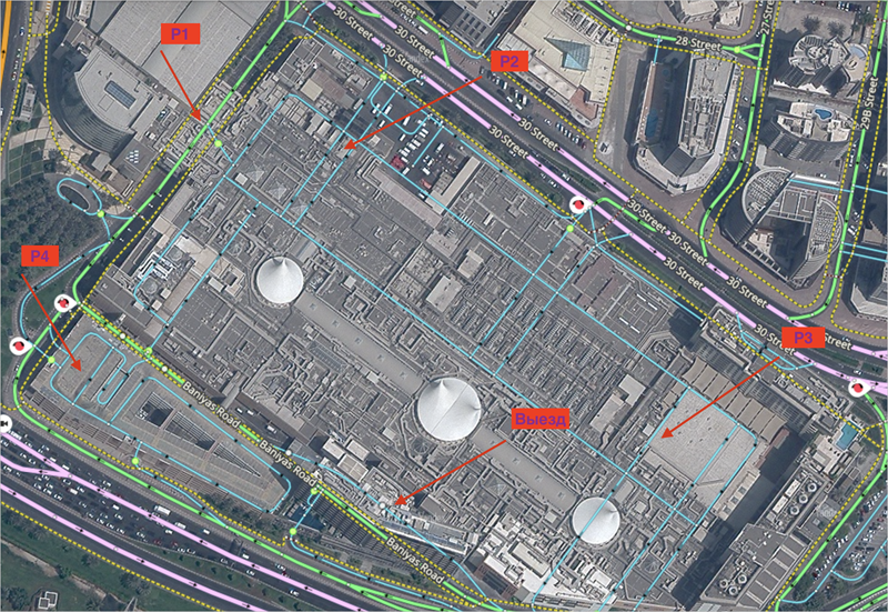
Map all existing entrances to free-standing parking lots belonging to shopping centers. If there's no accurate information about traffic inside the parking lot, map the road sections inside it as connected in order to ensure graph connectivity.
If the entrances are on different levels and there's no accurate information about traffic inside the parking lot, connect the entrances at each level separately.
The picture shows a shopping center with three entrances to the parking lot on level 1, two entrances to the parking lot on level P3 (with a separate entrance for taxis), and one entrance on level P4.
Exit from the upper floors is only possible at level P3.
4.8.3.4
- For the UAE, named exits should be assigned only their official name: keep the name for the caption blank.
4.8.3.5
- Long streets that span several municipalities are drawn as different streets within each of these municipalities and are linked to them.
4.8.3.6
- In the UAE, intersections do not terminate the effect of road signs. A sign remains in force until there is a sign that explicitly terminates its effect.
4.8.3.7
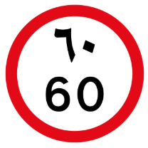
-
In the UAE, some speed limit signs indicate the speed limit in two languages. They are considered equivalent to standard speed limit signs.
4.8.4. Administrative divisions
4.8.4.1
-
Localities and similar items that completely cover the entire territory of the UAE and are the smallest administrative division units that are used to divide the entire country (both within and outside cities), including city districts, are mapped as items with the
Locality
type (level 4) with the Is a municipality option selected.Level 3 administrative division units (District) are parent for level 4 items (Locality).
4.8.4.2
-
For level 7 administrative divisions (Blocks), the
Has no official status
attribute is assigned to:- Villa complexes.
- Small blocks that have a name with a number and that are part of a larger block with the same name (does not apply to parts of districts and municipalities).
4.8.5. Locations
For official names of items in this category, we recommend including the type of organization along with its proper name.
When specifying the item type in the official name, enter the name for the caption without the type.
You should specify names in English.
4.8.6. Addresses
4.8.6.1
-
You can duplicate addresses on the map if one or more duplicate addresses meet both of the following conditions:
- They are the addresses of private houses (villas).
- They are linked to another parent item, but there's no way to determine the item name using available sources.
4.8.6.2
-
For villas that are part of a standard housing complex as well as those that have a number and a unique address, draw an address point and link it to the administrative division item of the
Block
type that was previously created for the villa complex.
4.8.6.3
- Map small residential buildings and apartments, including those that have their own name, as address points linked to the minimal administrative division unit they're located in.
4.8.6.4
-
If a street name contains a letter, don't include it in the building number.
For example, if the address plate says
Al Khalas-Frond B Street 7
, specify the street name asAl Khalas-Frond B Street
and enter7
as the building number.
4.8.6.5
- You can create addresses in formats like 001, 002, and similar, provided they are confirmed at the physical location or in official sources.
4.8.7. Forbidden locations
For Saudi Arabia and Kuwait, the following items must not be captioned or mapped as Locations
, Territories
, or Fences
:
- The royal palace and objects related to and located within the royal court, as well as princes' palaces in various regions.
- The Majlis ash-Shura (Consultative Council).
- Scientific research centers and biolaboratories.
- Oil refineries and their infrastructure, as well as oil and gas terminals, oil depots, and oil storage tanks.
- Liquefied gas storage facilities.
- Military and defense structures.
- Rocket launchers, munitions, and other Air Force facilities.
- Facilities related to state security (including the national security center).
- Facilities related to the General Intelligence Presidency.
- Nuclear facilities.
- Areas of nuclear mineral deposits.
- Aerodromes, runways, taxiways, aprons, and aircraft control facilities.
- Aircraft hangars on the Air Force airfields, blast-proof bays and aircraft shelters, operational area, headquarters, ammunition depots, fuel depots, and aircraft refueling facilities.
- Radar systems and units.
- Any naval facilities.
- Water mains.
- Electrical substations.
- Communications towers.
- Desalination plants.
- Space centers.