Public transport routes and stops
You can see public transport routes, real-time traffic, and public transport stops in Yandex Maps.
For more information on how to save the routes and stops that you use regularly, see Routes and stops.
Choose route
-
In the top-right corner of the page, click
 .
.Vehicle markers will appear on the map. For example:
-
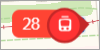 — The 28 tram moving east.
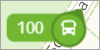 — Bus 100 traveling northeast.
-
-
Available modes of public transport are displayed in the side menu.
To view the current routes, click the desired mode of transport. You'll see the route options both on the map and in the side menu.
-
Select the desired route number.
The route card with a list of stops and a schedule will be displayed in the side menu, and the route line with moving vehicles will be shown on the map.
-
To track public transport in the Yandex Maps mobile app, click Try in the side menu.
For more information, see Send a notification to my phone.
Choose a stop
Click on the desired stop in the side menu or on the map. The stop card will appear on the left. On the map, the stop will be marked with a blue icon.
Note
In the stop card, your saved routes are displayed first.