3.5.1. Rules for drawing addresses
When drawing addresses, the following rules should be followed:
3.5.1.1
Don't duplicate addresses linked to the same item.
For example, there should not be two addresses named 1
that are linked to Iunost Square in Zelenograd.
3.5.1.2
When creating and editing shapes, place address points within the boundaries of buildings based on the actual situation on the ground. If possible, try making sure that the polygon of the building (for which an address point is being created or edited) matches the shape of the building on the ground.
If the address point is located within the building's polygon, you can't move it outside. If, during editing, the address point gets outside the building's polygon, you need to correct the building's shape.
However, some address points are exempt from this rule, such as:
- Address points related to buildings or structures not mapped as items of the
Building
type (such as bridges, underground pedestrian crossings, and other underground structures); - Address points related to buildings not mapped in Yandex Map Editor yet.
- Address points corresponding to an area rather than a specific building inside the area. See also 3.5.1.5.
3.5.1.3
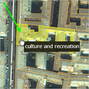
Address points should be mapped in the middle of the footprint of the building to which it belongs.
It's preferable to avoid overlaps of address points with each other and with other places, such as items in the Places
category. Also see Section 2.5.1. Placemarks: drawing techniques.
If an address point is placed at the center of a building's footprint and overlaps with a Locations
or Transportation
item, then it's preferable to shift the address point (not the item) from the center to eliminate the overlap. If an address point is placed in the center of a building's footprint and doesn't overlap with other placemarks, then shifting it from the center is unacceptable and would be considered a mistake.
Note
The geometric center of a building's footprint is the preferred reference point for the building's center.
Alternatively, the middle third of the building in terms of width and depth can also be considered its center. If an address point doesn't overlap with any other placemarks, shifting it from the geometric center to any other position within the middle third of the building in terms of width and depth is unacceptable and considered a mistake.
Example
You don't have to eliminate conflicts between address points.
3.5.1.4
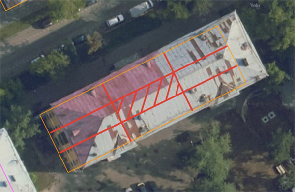
If an address is not assigned to the entire building, but rather to each of its individual entrances (such as in Kaliningrad), then all address points should be located on the line that runs parallel to the longest side of the building:
3.5.1.5
If one address is linked to several buildings in an industrial zone, then place the address point at the main (administrative) building.
3.5.1.6
If one address point is linked to several buildings connected by passageways, we recommend placing the address point at the building where the main entrance is located:
3.5.1.7
If one address point is linked to a building with wings, we recommend placing it at the main building:
3.5.1.8
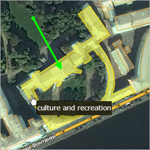
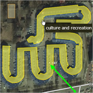
If an address point is linked to a building with a complex shape, we recommend placing it on the part of the building that runs along the road (picture on the left). If there's no such part (or the object's shape is too complex), it's preferable to place the address point closer to the building's geometric center (picture on the right):
|
|
|
3.5.1.9
- If two or more addresses correspond to the same building:
3.5.1.9.1
-
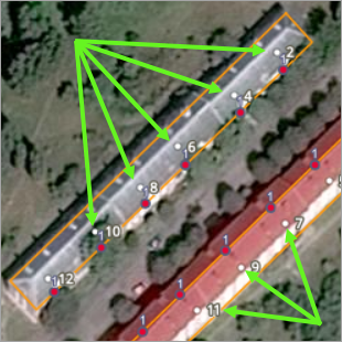
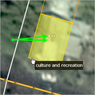
If a building has two or more addresses and its footprint has a shape of a square or rectangle, we recommend placing the address points next to each other in the footprint's center:
3.5.1.9.2
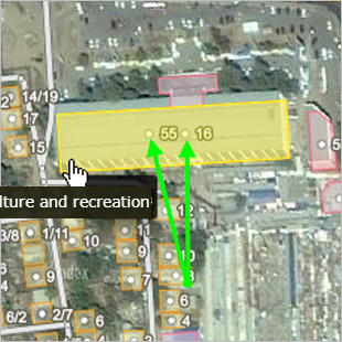
-
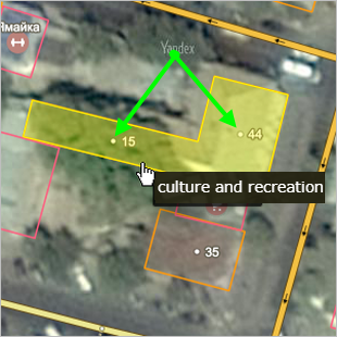
If a building has two or more addresses which correspond to different streets and its footprint is made up of rectangles (for example, it's T-, U-, or L-shaped), then the address points should be placed on the footprint's edges in such a manner that each point is
closer
to its associated street.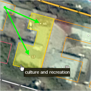
3.5.1.10
If a building is demolished and erased from the map (see 3.1.1.3) and the area the building was located in is being redesigned, you must also delete the address point associated with it.
If an area is vacant after its buildings have been demolished but still retains its address according to official sources, then its address point must be kept as is. However, if the area itself becomes inaccessible after the subsequent redevelopment, then the access point should still be removed. See also point 3.5.1.12.
3.5.1.11
Don't mark addresses whose numbers are not known.
There should be no address points with the no address
and no number
attributes on the map even if official sources contain them.
3.5.1.12
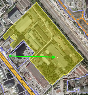
You can put addresses that are assigned to an area (territory) on the map, even if there are no buildings there.
For example, this could apply to newly formed cottage settlements where no construction has yet taken place.
3.5.1.13
You can draw address points for addresses used locally (even if they have non-standard details like pavilion, section, block, and so on) if they meet the following criteria:
Addresses of individual buildings:
- The address isn't a copy of another official address linked to another building.
- The building that the address belongs to either doesn't have an associated official address, or the official address is associated with another item (such as a street, block, and so on).
- The validity of the address can be confirmed by a sign located in the area, official documentation, or the website of a company located at the address.
- The address is linked to an item mapped in accordance with the Yandex Map Editor rules.
- The address includes only numbers and characters from the local alphabet.
Addresses used for parts of the building:
- The address isn't a copy of another official address linked to another building.
- The address includes details about parts of the building with separate entrances.
- The address is linked to an item mapped in accordance with the Yandex Map Editor rules.
- The address includes only numbers and characters from the local alphabet.
Addresses used for buildings within the same territory with a designated official address:
- The address isn't a copy of another official address linked to another building.
- The address includes details about individual buildings or parts of a building with separate entrances.
- The address is linked to an item mapped in accordance with the Yandex Map Editor rules.
- The address includes only numbers and characters from the local alphabet.
If the address is linked to the same item as the official address and doesn't include additional details, it is entered in the "Also known as" field
Note
Addresses whose parent items are organizations without a proper name are not marked on the map.
3.5.1.14
Addresses must be located within the boundaries of administrative divisions if:
- An administrative division is a parent item for the address.
- A parent item for the address (for example, a street) is located inside an administrate division.
This rule doesn't apply when the address is located outside the boundaries of an administrate division, and it's confirmed by the official documents.
3.5.1.15
An address that has a vegetation item as its parent must be located within the boundaries of that vegetation item.